Please attend the 08/27/26 Mobility Committee at City Hall 6PM.
Historic Shade Network, Climate Resilience, and Environmental Health
The Elenda Historic Neighborhood District tree canopy functions as a connected urban forest system, not isolated street trees. Urban forests are widely defined as networks or systems of street trees and other vegetation that form a backbone of green infrastructure and provide measurable environmental services.
What appears today as a beautiful residential landscape is, in fact, an intentionally designed and still-functioning historic shade network created through mid-century neighborhood design. Wide parkways and coordinated street plantings formed a connected urban forest that supports pedestrian comfort, environmental health, and neighborhood identity.
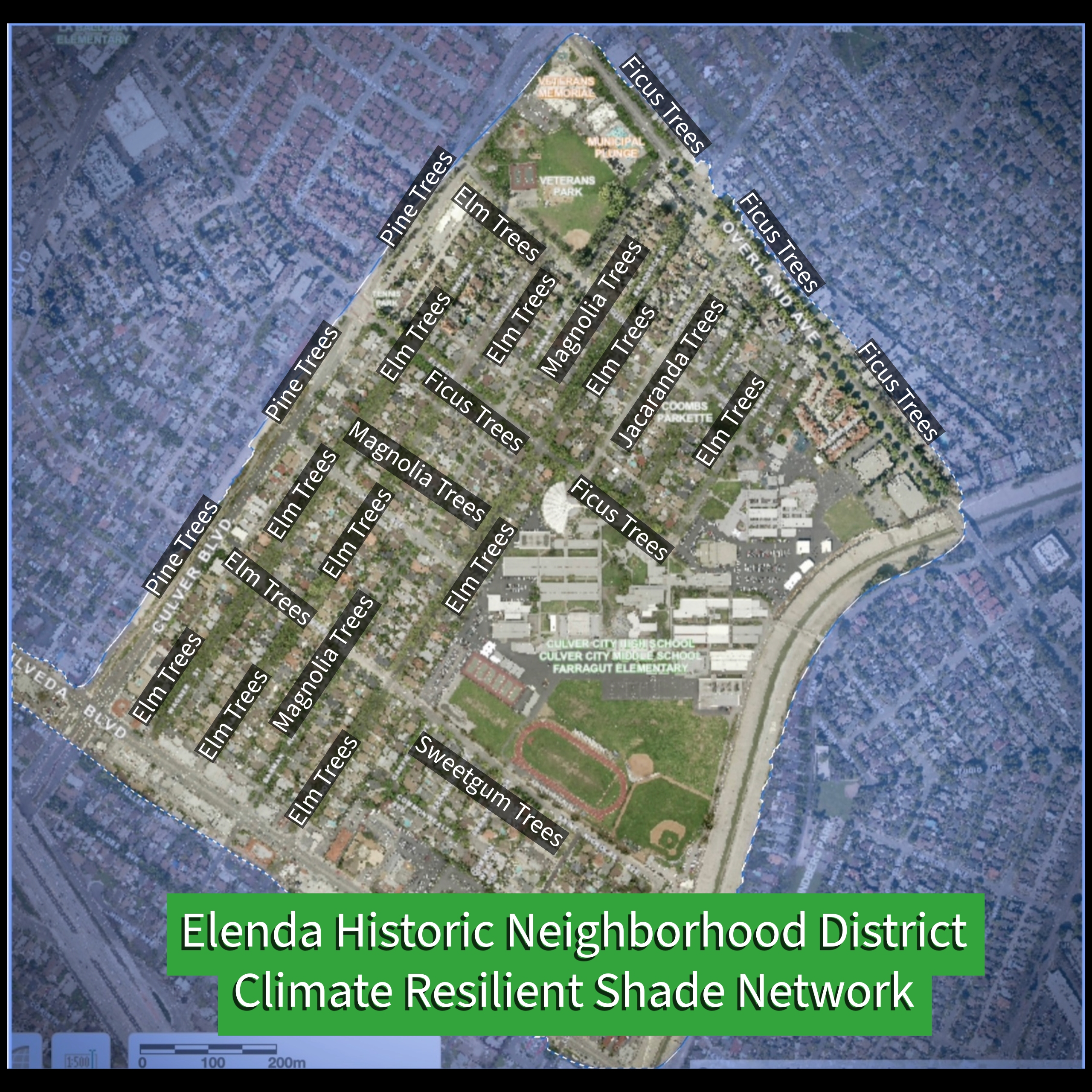
At the center of this network is Elenda Street, where seventy-eight mature Ficus microcarpa trees form a continuous canopy corridor, the living spine of the district's civic and environmental infrastructure. These trees also flank the neighborhood district on Overland Avenue. The Culver City Urban Forest Master Plan (2016) identifies this neighborhood district as one of the city’s most productive ecological assets, providing the highest per-species rate of air pollution removal in Culver City. These trees provide extensive shade for students and families walking between the tri-school campuses and the Robert Frost Auditorium, demonstrating how landscape design can function simultaneously as environmental infrastructure and civic space.
This central residential street anchors a continuous network of connected tree canopy corridors thereby enhancing a broader system of tree-lined streets that extend the canopy network throughout the district and into adjacent areas of Culver City.
To the west and south, Garfield Avenue contains forty-six Jacaranda mimosifolia, while Farragut Street and Franklin Street support a combined fifty-eight Ulmus parvifolia. These corridors connect Elenda’s central canopy to additional shaded routes within the neighborhood.
Further south, Braddock Drive contributes seventy-six mature elms, creating a substantial secondary belt of canopy that strengthens the continuity of the district’s urban forest.
Within the historic district itself, additional streets reinforce this pattern. Barman Avenue is lined with more than sixty Magnolia grandiflora, while both Lindblade Street and Wagner Street contain substantial groves of Ulmus parvifolia, each with more than fifty mature trees. These corridors mirror the canopy corridors on Farragut and Franklin and further extend the shaded landscape that characterizes the district.
Together, these streets form a continuous, multi-street canopy system connecting hundredds of mature trees that function at the neighborhood scale.
Climate Resilience and Environmental Infrastructure
The Elenda Historic Neighborhood District’s tree canopy system provides significant climate and environmental benefits. Trees reduce local heat through shade and evapotranspiration, improving thermal comfort along walking routes—an approach explicitly recommended in public health heat guidance, including around schools and along transportation corridors.
Along Elenda Street, this matters because the corridor is a documented focus of school-area mobility and safety planning, connecting the tri-school area with civic facilities on Elenda, including the Robert Frost Auditorium.
Urban trees also filter airborne pollutants such as particulate matter, nitrogen oxides, and ozone, improving neighborhood air quality. In addition, large trees store carbon in their biomass and continue absorbing carbon dioxide as they grow.
These are not abstract benefits. The district's existing canopy already delivers measurable cooling, air filtration, and carbon storage at a neighborhood scale.
As shown in the district map, these neighborhood streets form a continuous shade network spanning multiple streets and connecting residential blocks to schools and civic spaces.
The environmental benefits of urban trees increase substantially as they mature. Large established trees provide far greater cooling, pollution filtration, and carbon storage than newly planted saplings. Because of this, preserving existing canopy is widely recognized as one of the most effective ways cities can maintain climate resilience in established neighborhoods.
In the Elenda Historic Neighborhood District, the canopy corridors formed by Elenda Street and its surrounding tree-lined streets already provide these environmental benefits at a neighborhood scale.
Environmental Health Considerations in Unpaved Alleys
While the tree canopy provides significant environmental benefits, nearby unpaved alley surfaces present a separate environmental health concern.
Unpaved alleys contain decades of accumulated vehicle-related residues in their soils, including petroleum products, brake dust, tire particles, and other urban pollutants carried by runoff. When disturbed, these materials can become airborne, creating avoidable exposure risks near schools and pedestrian routes.
This process, known as dust resuspension, can release particles that have accumulated in the soil over many years. Near schools and pedestrian routes, this raises environmental health concerns because children and families walking nearby may be exposed to airborne dust containing these contaminants.
Stabilizing alley surfaces through paving can help reduce soil disturbance and limit the potential for contaminated dust to become airborne. In this context, paving alleys can serve as a basic environmental health measure that helps protect pedestrian areas near the school zone.
A Living Environmental Landscape
Together, the district’s historic shade network and its mature urban forest demonstrate how earlier neighborhood planning integrated environmental design with civic life. Wide parkways, coordinated street plantings, and school-centered walkability created a landscape where urban form and environmental function reinforce one another.
The Elenda Historic Neighborhood District is an existing, functioning model of climate-resilient, human-scaled urban design. Its interconnected canopy corridors provide shade, improve air quality, and support neighborhood climate resilience while maintaining the walkable character that has defined the district for generations.